Showing posts with label Hiking. Show all posts

13 July 2020

The Pride Of Madeira at evening time

The uninformed tourist usually associates Madeira with the localy cultivated Strelitzias or Birds Of Paradise (Strelitzia reginae), just because, due to its obvious beauty and visual impact, it's the flower most commonly seen in markets, shops or touristic events. However, in good truth, this plant was never endemic to Madeira, originating from South Africa and nowadays with a global distribution in nearly every warm and sunny temperated and tropical climates.
Therefore, if we would be asked to name a flower that truly represents the beauty and diversity of Madeira's flora, I'd say that the Pride of Madeira (or Massaroco, as locally known) would come to mind.
A true native to the island of Madeira, the Echium candicans is as beautiful as a wild plant can be and  it is a true delight to see alongside the roads in some urban areas or along the trails on the mountainous regions. Blooming happens between late Spring and early Summer and by the end of July most of their beauty is already gone, vanishing into dryness until the next year. Meanwhile, before that fading moment happens, its ephemeral flowering phase is a pleasure to our eyes and to bees as well, considering the abnormal attention these little bugs give to this particular plant on the course of their pollination duties.
Picture taken near Encumeada Alta, returning from the usual Pico Ruívo hike, at sunset time.
Nikon D300 and Sigma 17-50mm F2.8 EX DC HSM. Manfrotto XDB190 tripod and 490RC4 ball head. Flash Godox TT685N.

27 March 2020

Fanal - The pristine nature

Some years ago, motivated by a off-duty morning that was promising to be another waiste of precious and useful time if I stayed at home, I drove to the high plateau of Paúl da Serra, with the Fanal Laurissilva rain forest as the final destination.
Approaching this pristine parcel of nature for the first time was indeed a surprise, especially driving along the recently-built ER 209 (Regional Road 209). This strip of tarmac snaking along the primitive forest, particularly the length between Paúl da Serra and Ribeira da Janela, is also a delight to ride if you are a biker:


Nearby, and in a mostly paralell track alongside the ER 209, the PR 13 hiking route is a charming and easy-going trail, suitable for all of those who want to have an  all-around introduction to the Madeira pedestrian nature tourism with the least phisical effort. Just make sure, in advance, that the weather is clear. Most of the times it isn't. Fanal is well known for its foggy weather:


Albeit being a well preserved natural landscape, the Fanal forest also has its share of human presence. Althought not as intensive as decades ago, the pecuary activity still survives in this corner of the Madeiran territory. Shepherd's shelters are common as is livestock alongside the road. All this adds to the enchantment of the place. Just drive safely and slowly, avoiding stressing the animals:


Pictures taken with Nikon Coolpix P7100. Post-processing in Adobe Photoshop Lightroom and Adobe Photoshop.

27 November 2016

Dreams of Aneto

(Or the affective life of the Pyrenean marmots)

A street in the mountain town of Benasque.
 
Benasque was a dream of youth. An almost mythological place which name I used to whisper, in an age when the world still seemed infinite and my childish future career plans were a crossing between Galen Rowell and Sir Edmund Hillary. To a kid of fourteen who had never left Portugal, the Pyrenees might as well be in Bhutan.
Meanwhile, amongst readings of well-intentioned authors and day-dreaming, I got older. And like the vast majority of the human race, while we progress in life, from beginning towards the unavoidable ending, we have the sad tendency to replace romantism for pragmatism.
Like a very personal and intimate civilizational crash, to me that happened abruptly around my twentieth birthday.
Someone once told me that “in a family the younger child does what he wants to do and the older one does what he has to do”. Being the older brother in the family I knew what I had to do, alright: achieve my independence as soon as possible.
So at twenty I was choosing seafaring life over bum life (for some, they aren’t really that different, you know?) and a few years Iater I was finally living a totally independent life. On the side of that path I left a few (questionable) dreams.
The Renclusa hut. Departing point for so many adventures in the Posets-Maladeta massif...
...and the cool marmots living on the neighborhood.

Well, although I may hold some bitterness for a dreamt future never fulfilled, truth is I’m glad, so far, how things turned out and the Earth’s spinning movement drove my life to the present moment in time.
To me, for decades, and pardon my lack of ambition, the Aneto was my “Everest”. As the actual Everest is the Everest for so many.
The Mahoma step in front and the last problem before the summit.

Now, twenty-six years and kilograms later from my first visit to the biggest Iberian cordillera, I was finally standing at the top of the Pyrenees highest peak, after a seven-hour climb from La Renclusa (well, it was more like a high-mountain hike) and wondering why was I so lazy in the last quarter of a century.
After kissing the Virgen del Pilar statue that adorns the summit and while looking East, to the uncomfortable Mahoma step I’ve just crossed and to all the people following the same path, I finally understood it.
Like Monte Perdido, that I ascended twenty-six years ago, and, perhaps, the iconic Mont Blanc, this wasn’t just a climb. It was a pilgrimage.
Far from being just, in the words of legendary French climber Lionel Terray, “conquests of the useless”, there’s a lot to be learn, on a spiritual level, about such accomplishments.
We are living in an Era with fewer geographic boundaries to overcome. With less and less blank spots on the world map to be cartographed, and the progresssion curve of human physical capabilities leaning slowly to the horizontal plane, we find ourselves slowly steering from the Neanderthal-like bravado to a more spiritual level.
The statue of the Virgen del Pilar looks at the distant horizon from the highest summit in the Pyrenees in a particularly peaceful June morning.
 
The same also happens in mountaineering, where, after all the important conquests have been achieved, the only objective still worthy of a look is the ascension of Everest during the winter season, oxygeneless,  solo and… errr… bare naked.    
In the end, regardless of the narcissists’ childish opinions, reaching the high peaks accounts for just that: a deeply personal, metaphysical and spiritual experience that, hopefully, will bring a bit of light to the mysteries of our lives and, by that, perhaps, contributes to give us a better understanding of ourselves and the others.
But, above all of that, within the most intricate corners of our souls, we all secretly believe that it will lead us closer to God.
 
All the pictures taken with Nikon P7100

24 September 2014

From Pico do Areeiro to Pico Ruívo - PR 1 - The new route

As I mentioned in an earlier post, the trail between the two highest peaks in Madeira is open, since last April, for traffic, following the repairs that took place after the landslide. Today, six months after the conclusion of the work, the opinions regarding its effectiveness diverge, being most of the hikers skeptic about the durability of the chosen option: the construction of a whole new section of the trail, instead of repairing the damaged one. Many believe the new route will not survive the Winter season approaching and the consequent worsening weather conditions. Time will tell.
Regardless of the decision's technical questionability, the fact is this was a strenuous work for a group of construction workers, since all the materials, due to the remoteness of the location, had to be carried by human portage, including an eighty-kilograms generator.
The photos below, taken one day before the official public opening, gives us a vision of the structures built in-situ to surpass the terrain obstacles.
Picture above:
On the afternoon of the last working day, a team of surveyors and construction workers retreat from the newly-finished trail and head on to Achada do Teixeira, ending an intervention that lasted nearly four months.
All photos taken with Nikon D40X and cheap Nikkor 18-55mm DX kit lens. Post-processing of the NEF to TIFF converted files in Adobe Photoshop Lightroom.

13 September 2014

Levada dos Cedros - P.R. 14

The Levada dos Cedros has one of the most handsome sources in all the Madeira's levadas. However, as strange as it may seem, this path is not as visited as its nearest neighbours, in Rabaçal valley. Hidden deep in Fanal, this hike is, nevertheless, a pleasurable one, taking you deep into the Laurissilva forest.
The departure point to Levada dos Cedros source, nearby the ER 209 (Regional Road).
 
Description:
Departure position:
Lat:   32º49'33"N
Long: 017º09'29"W
Altitude: 870 mts
Source (arrival) position:
Lat:    32º47'57"N
Long: 017º08?39"W
Altitude: 910 mts
 
Distance: 5.4 kms
Time:       aprox. 1h30m
The round hike (from departure to departure) will take you about three hours on the trail and nearly eleven kilometres of walking.
 
Wooden bridge in Levada dos Cedros...
The always luxurious vegetation is a constant presence, as we proceed deeper into the Laurissilva, heading to the source of the levada.
The remote and luxuriant source of Levada dos Cedros, deep inside the primeval forest of Fanal. A well-kept Garden of Eden, rightfully deserving a visit and the 5.5 kms long approach march.
Pictures made with Nikon D40X with Nikkor 18-55mm kit lens and Nikon Coolpix P7100. Tripod Sirui T005 for the last picture.
Post-processing of the converted Nikon NEF Raw to TIFF files in Adobe Photoshop Lightroom, ver. 4.1.

10 April 2014

P.R. 1 is now open

Concluding a strenuous work which started on the past January, a team of construction workers finished today the repair of the most celebrated of all the Madeira mountain trails: the PR 1, connecting the highest peaks of Madeira.
Just in time to be ready for the present year's edition of the MIUT (Madeira Island Ultra Trail), scheduled for the next Saturday, the repair operations suffered several meteorological setbacks, namely rainy and snowy conditions, forcing the constructers to slow down.
Well, better later than never. And the island's trail event, growing famous year after year, will, once again, have on its route the notorious path connecting Pico Ruívo to Pico do Areeiro.
The Pico Ruívo mountain hut will be, once again, a mandatory passage for all the athletes participating in the present year's MIUT. Here pictured yesterday, at midnight, during a particularly amazing and clear blue sky.
Picture taken with Nikon D610 and Sigma Aspherical 24mm f/1.8 D EX DG Macro mounted on Sirui T-005 travel tripod and ball-head.
Post processing in Nikon View NX2 (conversion from NEF to TIFF) and Adobe Photoshop Lightroom, ver. 4.2

17 February 2014

Madeira - First Snowfall of 2014


A few pictures of the first snowfall of the present year of 2014 in the mountains of our Madeira island. The pictures were made yesterday (the 16th), in a short walk during the afternoon, when the roads to the central massif were opened by the Forestal Police and the Civil Protection, thus enabling us to hike from the Achada do Teixeira plateau to the Pico Ruívo mountain hut.
The conditions for photography were not the best, because the afternoon on the mountain was grey, windy and wet.
So we skipped the visit to the peak itself, since it served no purpose whatsoever. We remained in the mountain hut area, trying to make the best of the winter conditions laying in front of us.
Through all the hike the air temperature varied between 0ºC and +2ºC and the humidity remained near 100%.
Pictures made at a altitude of 1775 mts, near the mountain hut, with a Nikon D40X and cheap Nikkor 18-55mm f/3.5-5.6 AF-S GII ED DX kit lens. Post-processing in Nikon View NX2 and Adobe Photoshop Lightroom, ver. 4.1.

17 October 2013

Pico do Areeiro to Pico Ruívo trail (PR1) closed

Due to a landslide on the past weekend, in a position about 1 km down from the Pico Ruívo mountain hut, the Pico do Areeiro-Pico Ruívo mountain trail (PR1) - the most important of the island - is closed to hikers.
And since the landslide happened in a position already near the end of the trail (if you are arriving from Pico do Areeiro) and well after the tunnel that divides the route into two, this, now, makes the trail totality impassable.
Hopefully, the government responsible persons are aware of the problem and already adopting an active attitude (the sooner, the better) towards the resolution of the situation.
After all, this is only the most important mountain trail in a island with nature tourism as its most important asset.
Landslide picture taken from the nearby (and shorter) Achada do Teixeira - Pico Ruívo route (PR1.2), with a Panasonic Lumix GH 2 and Nikkor 28-105mm AF-D with adapter to m4/3. Handheld shot at ISO 2000 (sorry for the noise and lack of detail!).

26 September 2013

Levada do Caldeirão Verde and Caldeirão do Inferno

The Levada do Caldeirão Verde and Caldeirão do Inferno (P.R. 9) is, probably, one of the longest levada walks that you can make in Madeira.
From the Queimadas forest house to the Caldeirão Verde source and back you can count a good 13 kms. However, if you decide to start your walk in Pico das Pedras and ending it in Caldeirão do Inferno, you'll end the day with a good twenty kilometres under your soles.
Most of the time, you will walk under a dense canopy of luxourious forest and crossing a few short tunnels along the way. After reaching the Levada do Cadeirão Verde source you can continue upstream for another two kilometres of dry levada channel and one exhausting staircase until you reach the Caldeirão do Inferno source and canyon; one of the most dramatic scenarios that you can see in Madeira.
One of the starting points for this classic levada walk is the Queimadas forest house, located near the city of Santana. As one of the most frequented levadas in Madeira, finding a parking place for the car in mid-Summer and during the weekends in the nearby (small) parking area can be an almost impossible task. To avoid this discomfort, many hikers choose to park their cars two and a half kilometres away, in Pico das Pedras, and walk the stretch of levada between this site and Queimadas. That will cost you about four kilometres more at the end of the day.
Plenty of vegetation and abundance of water, either in Summer or during the wet season. This is the characteristic ambiance along this particular levada walk.
The Caldeirão Verde source, in a picture taken from the dry (at the time) levada channel leading to the Caldeirão do Inferno. The dense vegetation is omnipresent, giving to Madeira a sense of being an Atlantian Hawai. Or is it Hawai a Pacifian Madeira?
The Caldeirão Verde birth place, with its impressive one hundred meter waterfall and pond, is the spot where everybody eats a snack before venturing further deep in the mountain, up to the Caldeirão Verde, or just returning back to the departure point.
The Caldeirão Verde/Caldeirão do Inferno levadas  are one of the most complex hydraulic systems in Madeira. After climbing the exhausting staircase I've told you about a few lines ago, you reach this... let's call it... main square at, nearly, 985 metres above sea level. On this crossing, you'll notice three tunnels for three different destinations. On your left you see the entrance to the tunnel leaving you upstream, for about 1km, up to the source of the Levada do Caldeirão Verde (not the one you've made, but a smaller, higher, homonymous one). In front of you, if you follow with your eyes the railway tracks that once supported the wagons used to build it, lies the entrance of the Pico Ruívo tunnel and levada. One of the longest in Madeira, it was carved underneath Madeira's highest peak (hence the name) and has the function of feeding water to the Fajã da Nogueira hydroelectric power plant, built in 1971 on the opposite valley. With almost 2500 mts, you can expect a good 45 minutes underground if you plan to, like I did, traverse it.
Finally, on your right you see the third and last entrance on this crossing. This is the one you want (for now) to follow upstream for about 980 mts and a ten minutes walk up to the source of Caldeirão do Inferno.
The Caldeirão do Inferno is, by itself, a system within the system. It's a complex water collecting net, comprised of a few small dams and water channels, built with ingenuity in one of the most remote places in Madeira and right in the heart of the Laurissilva forest. In this spot, staring at one of the many waterfalls that abound in this place, you've reached the end of your present hike. Time to eat one last snack, drink some water and prepare your mind for the three hour walk back.
Pictures taken with Nikon D300, D40X, Nikon Coolpix P7100 and Nikkor 18-55 and 55-200 kit lenses.
Post-processing of converted NEF to TIFF 16 bit files in Adobe Photoshop Lightroom, ver. 4.1.

08 September 2013

Levada das 25 Fontes

Travelling to Madeira and not hiking the Levada das 25 Fontes it's like visiting Rome and not seeing the Pope. This levada, located in the North-western coast, in the Rabaçal area, is probably - together with Santana's Caldeirão Verde (more on this one soon) - the most famous in Madeira.
And (if you forget the long approaching march, by a two and a half kilometre tarmac road, from the parking lot to the Rabaçal forest house) one of the most enjoyable.
Like I said, after parking your car in the parking lot near the water chamber of Calheta's hydroelectric power plant, you proceed downhill along the tarmac road and heading to the Rabaçal forest house.
Once there you'll catch the trail leading you to the levada level, a couple hundred meters below. From here a shorter route will lead you to the Risco waterfall and the longest one will take you to the 25 Fontes source. My advice: explore both. Just don't forget that's going to be a long way back. So start early.
Whith good parking conditions, on the Paúl da Serra plateau, and therefore easily reached by car, the Levada das 25 Fontes is a good introduction to us, nature lovers, on the biodiversity of Madeira. Along this easy but long walk, you'll have the chance to look around, to your heart's content, for plants...
...insects...
...and birds.
Just make sure that you bring with you, for the trail, either in Summer or Winter, an adequate supply of "bom-dia's", "bon-jour's", "hello's", "guten tag's and guten morgen's, "ciao's" and "hola's" (just to name a few). You'll surely going to need them.
Being one of the most popular in Madeira, the Levada das 25 Fontes can be, sometimes, a little bit crowded. Ohh, well... this is also part of the fun. Picturing the levada's source, on a, somehow, busy Summer day.
All pictures taken with Nikon D40X and Nikkors 18-55 and 55-200 kit lenses. Post-processing in Adobe Photoshop Lightroom, ver. 4.1 of TIFF images, converted from NEF files in Nikon View NX2.

04 September 2013

Madeira fauna

A few days ago, I went back to the P.R. 1. This time alone, I, once again, trekked the most demanding of all the Madeira hikes: the route between the Pico do Areeiro and Pico Ruívo (see From Pico do Areeiro to Pico Ruívo and back in this blog). It was not my intention to beat the times of our most competent trail runners. I don't have the guts for that. However I did manage to hike it (in a fast pace) in about 1h 36min and choosing the longest route (by Pico das Torres). Not so bad, I guess, for an out-of-shape guy. The route is about 7 kms in length and since I had to return to Pico do Areeiro (had the car there), I ended up doubling that distance and it was almost sunset when I finally arrived to the departure point, located close to the Radar Station nº4 of the Portuguese Air Force.
On the way back, and with the mountain in almost absolute silence (at the time I was alone in the trail) I had a surprise close encounter with representatives of the local fauna: a cool band of partridges.
I remember going hunting, when I was a child, with my granddad. Besides wild rabbits, partridges were our most wanted trophies. Back at home, my grandma would then make some nice stews with them.
Although I did love those hunting "expeditions" with my grandfather, as I got older I developed an ecological consciousness that led me away from hunting. But I do miss those days I've spent with him.
So, imagine my surprise when I saw this flock of about a dozen partridges appearing right in front of me, a few minutes after passing the Pico do Gato tunnel. And contrary to what I remembered from my childhood, these were the coolest partridges I've ever seen. So cool that I sat down in the stairs for almost an hour to photograph them, while they were eating some wild flowers a couple of meters away from me. Fearless. Just like domestic chickens.
How lovely is nature when everything is in harmony.


The Radar Station nº4, of the Portuguese Air Force, in Pico do Areeiro (1818 mts above sea level), is both the starting and arrival point of the P.R. 1, the trail connecting Madeira's highest peaks.
All pictures taken with Nikon Coolpix P7100 and post-processed in Adobe Photoshop Lightroom, ver. 4.1.

07 August 2013

Hard work

Mountain huts, by definition, are located in the most remote areas of the globe. Their inaccessibility is, somehow, part of their charm.
Most of the times they can only be reached by air or walking through rough mountain trails. And that brings a problem when we think about the need of supplying them. Regarding that aspect, there are only three solutions: using helicopters, pack animals or sheer human force.
Mr. José António, the Pico Ruívo mountain hut guard, carries a supply cargo (in the old fashion way), along the trail from Achada do Teixeira to Pico Ruívo.
Picture taken with Nikon Coolpix P7100 and post-processed in Adobe Photoshop Lightroom, ver. 4.1

27 June 2013

Levada do Norte

The Levada do Norte is not for the faint-hearted. One of the longest in Madeira, it starts in the hydroelectric power plant of Serra de Água and snakes along the middle of the thousand-meter vertical rock wall rising above the left margin of the Ribeira Brava stream, crossing several tunnels and vertiginous precipices, before reaching Boa Morte and entering in a more relaxed and man-made landscape. Five or six years ago, I was feeling courageous enough to attempt it. And so I did. But it was a scary experience (although with lovely vistas). And I'm not a person, normally, scared with heights. But the section of this levada passing right above the village of Serra de Água is enough to make (even for the bravest of "levadeiros") us think twice. It's the verticality, it's the exposure, it's the height above the far, far... away ground. If it's difficult for us, nowadays, to walk through, one can only imagine how hard it was to build, sixty years ago. Those were brave people. No doubt about that.
Well, I did it once. And, for the time being, once was enough.
However, I was missing it. And so, a few weeks ago, I decided to repeat part of it. Just a small section. Between Boa-Morte and the small village of Espigão.
With a length of 8 kilometres (sixteen in total, if you plan to return back by the same way), it's a good introduction to this levada and to the fabulous landscapes we can see along it. And you can always drink a beer or a coffee, at the beginning and at the end of the walk in the nearby friendly bar "O Pinheiro".
A sign plate, near Boa Morte, orients you to the Levada do Norte. Eastwards, it runs thru a humanized landscape of agriculture fields and small villages to Quinta Grande and beyond. On the other direction, Westwards, if you like strong emotions, the Levada do Norte will take you to its birth place, near the Serra de Água hydroelectric power plant, and after a walk along one of Madeira's most dramatic geological formations: the Ribeira Brava valley.
 
From Campanário and Câmara de Lobos to Boa Morte, the Levada do Norte mostly traverses a bucolic landscape of agriculture fields and small human settlements. A strong contrast with the more isolated, exposed and dangerous section laying upstream.
The small village of Eira do Mourão, one of the most remote in Madeira and once only acessible by a two hour long staircase walk, starting in the Ribeira Brava basin, stands isolated on top of a rocky ridge, high on the left margin of Ribeira Brava valley. Picture made from the nearby-passing Levada do Norte.
Pictures taken with Panasonic Lumix DMC-GH2 and cheap 14-42mm plastic kit lens. Post-processing in Adobe Photoshop Lightroom, ver. 4.1.

Starting the Levada do Norte from its source (near the Serra de Água hydro power plant) and our walk will be mostly under the canopy of a luxuriant forest. At least for the first miles. Until the village of Espigão there are also several tunnels to be crossed, the biggest of them all measuring a good 3 kilometres. Some of them are somewhat flooded. So be prepared for wet feet. And don't forget the torch light.
The most dramatic section of this very exposed levada is this one, right above the village of Serra de Água. In Winter time it's quite often impassable, due to the waterfalls that fall right on top of the levada channel. It's simply to dangerous.
In this picture made from the valley floor, near the Serra de Água village, you can have an idea of the exposure of this particular section. And how difficult it was, certainly, to be built.
A picture of this particular section, taken right from the track, a few years ago, during Spring time. You can still see the water falling right at the exit of the tunnel. The picture doesn't give justice to the exposure and verticality of the place.
The last four pictures were taken with a Nikon FM3A and a 28-105 Nikkor zoom lens. Fujichrome Velvia scanned in Nikon Coolscan V ED and post-processed in Adobe Photoshop Lightroom, ver. 4.1.


02 February 2013

Volcanic Earth

Massive telluric forces shaped the face of Madeira ages before we humans started to walk on the surface of the planet. Even today, while hiking in the pristine central massif of this highly humanized island, we have the feeling that we are facing the dawn of the Earth. We just need to climb above the clouds.
Picture made with Nikon F100 and Nikkor 28-105mm AF f/3.5-4.5D kit lens. Kodak Ektachrome 100VS scanned in Nikon Coolscan VED and post-processed in Adobe Photoshop Lightroom, ver. 4.1.

09 July 2012

The North Face of the Ogre

It's difficult to explain in a single picture the sheer respect imposed by this wall. You'll have to be there... nearby, at least. Since only a few in the world have the courage to tackle her.
You have to arrive at evening time to the town of Grindelwald, located in the valley beneath. And have a frightening first vision of the monster. A Swiss mountain guide to whom I've talked one day after my arrival told me that the mountain already lost most of her sinister fame. That, thanks to the efforts of the Swiss mountain rescue, nobody dies there for more than twenty years.
However it's hardly forgettable that more than sixty persons lost their lives in the "Wall of Death", since she was first climbed, in a four-days battle, by an Austrian and German team, in 1938.
Together with the Walker Spur, in the Grands Jorasses, and the North face of the Matterhorn, also in Switzerland, she belonged to an elite team of three called "the last great problems of the Alps". And she was the last to be vanquished.
There are higher mountains in the Alps. However, due to the combined forces of stormy weather, sheer verticality and objective dangers, the Eiger North Face is unique. A massive vertical monolith almost two kilometres high (1800 metres to be exact) rises above the Kleine Scheidegg grassy plateau, the typical point of view for the tourists. But the most dramatic vista is achieved while you are travelling on the mountain train that connects the town below to the hotels on the Kleinne Scheidegg.
The rack railway passes right beneath the wall, showing us the most dramatic mountain landscape in Europe. I was thinking to myself "how can it be possible to climb this?". And I, surely, wasn't the only one.
With my limited mountaineering knowledge I can assure you, however, that there are many eight thousand meter peaks "modern conquerors" that simply don't have what it takes to face this mountain. Because, before conquering her, they have first to vanquish their fear.
Because that's all that she is. Fear.
Self-portrait and the North Face of The Eiger, as seen from the Kleine Scheidegg grassy plateau, taken during my solo-Interrail through Europe. Winter of 1998.
Picture taken with beaten second-hand Pentax MX and cheap Cosina 50mm f/2, both bought for the voyage.
The camera was bought in an antique shop in Restauradores, Lisboa, and received a slight overhaul, prior to the voyage, in the professional and capable hands of the camera mechanics at Fresnel, a Lisbon-based repair shop.
Shot on Kodak Ektachrome 100VS Professional film and scanned on Nikon Coolscan V ED.
Post-processing in Adobe Photoshop CS3.

07 July 2012

On the Levada do Rei to Ribeiro Bonito

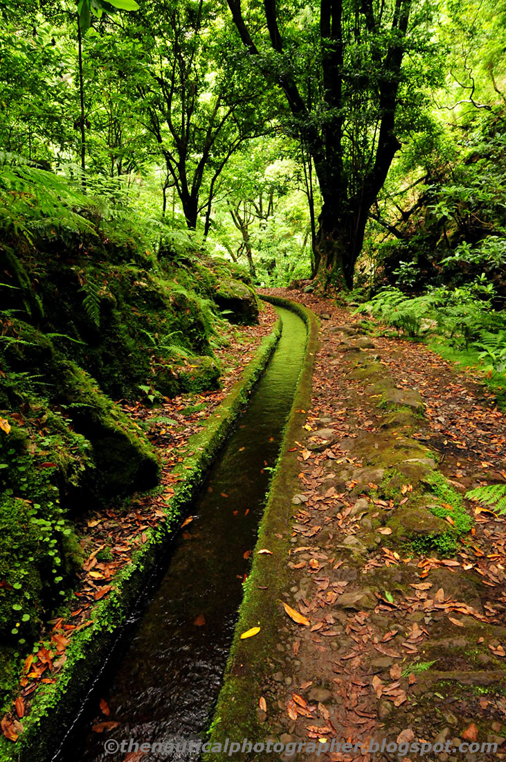
Levada do Rei is, probably, one of the most luxourious hikes that I had the pleasure to do in the mountains of Madeira. Since its beginning, near the water treatment plant of Quebradas, in S. Jorge, up to the end, in Ribeiro Bonito river bed, we walk along a misty primeval forest, deep in the heart of Laurissilva. It's a ten kilometres round tour along the typical Madeira enchanted forest. Or about three and a half hours in walking pace.
My hiking companion was talking about "Avatar", from James Cameron, and how much the ecological message within that movie was a strange paradox with the natural painting we were part of. According to her its message was quite simple: if we humans keep on despising the natural laws in a natural world in which bosom we also belong, the future will be our unquestionable extinction.
I really don't know why we started to talk about the film. Maybe the deep green forest we were in reminded her of the visually stunning natural scenarios of that multi-million dollar production. However that free association stops right there.
In a world where the word "sustainable" is breaking daily records on the written press, most of the times in a cry of despair, the "levadas" show to us all that is possible to disturb the natural equilibrium without destroying it.
And when we finally arrived to the starting point, about three hours later, we left behind a world of trees, flowers, birds and bugs. And a peaceful water channel running though it. A secular human work-of-art that confounds itself with the surrounding nature. And a creator of life.
Could this be the definitive sustainable human intervention?
Hundreds of years after their construction, the "levadas" are becoming a part of the natural ecosystem.
Picture taken with Nikon D300 and Sigma DC 18-50mm 1:2.8 EX Macro HSM Lens.
Post-processing in Adobe Photoshop CS3.
A major engineering achievement, the Madeira's secular irrigation system is a work-of-art. A testimony to human ingenuity and sustainable intervention in nature.
Picture taken with Nikon D300 and Sigma DC 18-50mm 1:2.8 EX Macro HSM Lens.
Post-processing in Adobe Photoshop CS3.
The "madre" (meaning "the spring") that feeds the Levada do Rei is located in the Ribeiro Bonito stream bed. Our hike ended here. Where the levada begins.
Picture taken with Nikon D300 and Sigma DC 18-50mm 1:2.8 EX Macro HSM Lens.
Post-processing in Adobe Photoshop CS3.
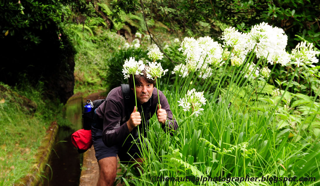
The author advancing through a serious thick jungle of Coroas-de-Henrique (Agapanthus praecox ssp. orientalis) during the first expedition to Ribeiro Bonito. We could hardly see an inch in front of our eyes :-)
Picture taken with Nikon D300 and Sigma DC 18-50mm 1:2.8 EX Macro HSM Lens.
Post-processing in Adobe Photoshop CS3.